APPENDIX E - Filling Out the Forms
This section is intended to clarify certain portions of the "Application for Certification of a Road Course."
Type of Course
Courses rarely fit the simple categories exactly. Attempt to determine the basic structure of the course with the following points in mind.
A loop course follows a path that eventually closes on itself with the runners headed in the same direction as they were at the start of the loop. This circular motion can be repeated indefinitely without the need for the runner to reverse his/her direction of running.
An out-and-back course follows a path out to a turn-around point where the runners are required to reverse direction and come back on the same roadway. When the out-and-back section is completed, the runners are headed in the opposite direction to that followed at the start of the out-and-back section.
A point-to-point course is defined as any course whose straight-line distance between the start and finish points is greater than 50% of the overall race distance or any course whose net decline averages more than 1.0 meter per kilometer (i.e., where the finish elevation lies below the start elevation by more than 1/1000 of the race distance).
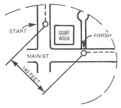
Straight-Line Distance Between Start and Finish
The straight-line distance between start and finish is the distance "as the crow flies" (see diagram below). This may be taken from a map drawn to scale by measuring with a ruler and converting to kilometers (or miles) using the map scale. Or it can be determined with just a few mouse clicks by using some of the newer online mapping tools.
The rules on eligibility for USATF and IAAF records make a distinction between courses with start-to-finish separation less than or greater than 50% of the race distance (such as 2.5 km for a 5 km race). If it appears that your course is close to this threshold, try to determine its separation more accurately. Your course can be certified either way; however, if the separation exceeds 50%, official records cannot be set on the course.
Altitude of the Race Course
Elevations of points on race courses have traditionally been obtained from topographic (“section” or “quadrangle”) maps produced by the U.S. Geological Survey (USGS). Unfortunately, these maps are getting increasingly out-of-date. USGS officially completed their series of 7.5-minute quadrangles in 1992 and has now replaced them with an online topographic map called the “National Map,” available at http://nationalmap.gov/. For information about this and other helpful online mapping tools, see our Certification Tools page.
Finding elevations from traditional topographic maps requires interpreting (and interpolating between) contour lines. Some of the newer online tools allow determining the elevation of a point simply by clicking on it.
Classic topographic maps show locations of prominent natural and man-made features. Some of the newer online tools supplement this information by providing satellite imagery. This can be very useful, as it may allow you to zoom in and make sure you’ve located your course’s start and finish points correctly. Note: you’ll probably find more available imagery if your course is in a major urban area than if it’s in a rural area.
The Application for Certification of a Road Course asks for four elevations: start, finish, highest and lowest. Of these, the start and finish elevations are most important. To find the high and low elevations, you’ll need to trace over your course route, as shown on the map, and check elevations at many points along the course.
Note: We are most interested in the difference in elevation between the Start and Finish; therefore, it is more important to determine this difference accurately than to get all of the individual elevations above sea level just right. Eligibility for records depends on whether the course has a net drop in elevation exceeding 1/1000 of the race distance (such as 10 meters for a 10 km race). If it appears that your course is close to this threshold, try to determine its drop more accurately. Your course can be certified either way, and will also be eligible for USATF "best" times either way; however, it must not drop more than 1 m/km in order to be eligible for official USATF "records."
Type of Surface
The various classifications are, for the most part, self-explanatory. The "undefined" surfaces are those which do not offer a preferred direction of travel, such as a large parking lot or an open field. Defining a course in such areas presents certain problems. Often these areas are traversed between prominent landmarks which provide guidance for measuring the course as well as laying it out on race day. If the route is straight, only the entry and exit points need to be defined. If the route is curved or uses several landmarks, such as light poles in a parking lot, the route must be coned and monitored.
| Go to Next Section: | Appendix F - Metric-Imperial Conversions |
| Previous Section: | Appendix D - Adjusting an Existing Certified Course |
| Back to: | Table of Contents |