APPENDIX C - Example of Course Measurement
Course Maps
One of the most valuable results of your paperwork will be your course map. Not only should it demonstrate to the certifier the manner in which you measured your course, but it should document exactly how the course is laid out and where the crucial start, finish, and turn-around points are located. (And remember that once the course is certified, your map will be posted online.)
The following examples of course maps demonstrate there are many ways to draw maps. However, they all clearly show how the course is to be run and where crucial points are located. Note in particular that each map shows how the shortest possible route was followed. This assures the regional certifier that the measurer was aware of and followed the shortest possible route in the measuring.
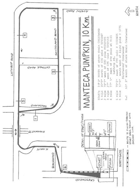
The Manteca Pumpkin 10 km shows a fairly simple keyhole course with only one S-curve (encountered twice) and two diagonals across traffic. Note the blow-up of the start/finish area. Note also that the runners are kept to the inside of the loop and are allowed full use of the roadway on all portions of this course. The lack of a 5 km split is a deficiency.
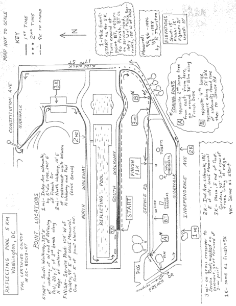
The Reflecting Pool 5 km is a complex course with many turns, some across grass. Note that each and every turn is defined by an object:
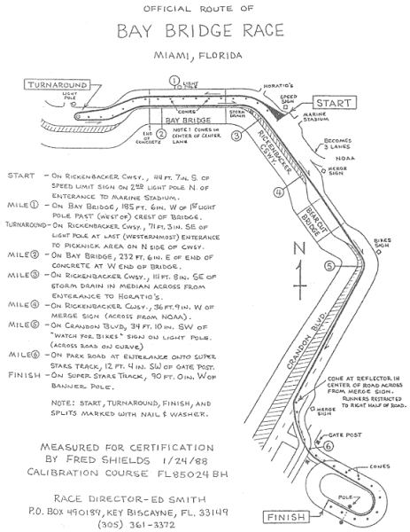
The Bay Bridge 10 km shows use of cones to restrict runners to one side of the road. Note that all splits appear on the map. This is desirable if there is room:
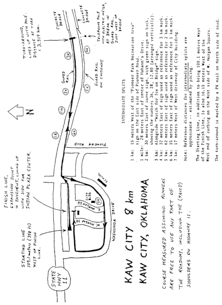
The Kaw City 8 km in Kaw City, OK illustrates proper measurement of a turn-around point. The course is classified as an out-and-back since only 20% of the course is a loop and the start and finish are 109 meters apart. Note the detailed description of the location of the turn-around point and metric splits.
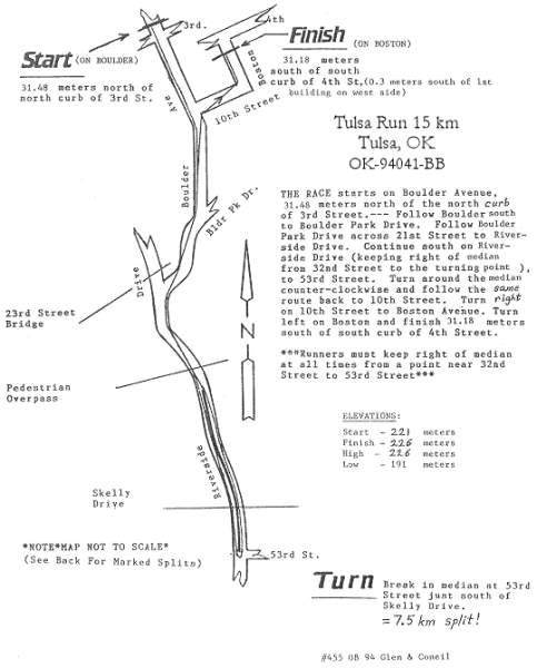
The Tulsa Run 15 km in Tulsa, OK is an example of a metric race conducted in a totally metric format. When the Tulsa Run adopted this all-metric format, they also adjusted (and re-certified) their mostly out-and-back course to place the turn-around at exactly halfway, so the kilometer splits going out and coming back would occur at the same points. The split points aren't shown directly on the map; instead, they are described in a separate list, which the certifier then photocopied onto the back of the certificate. This map also includes a text description of the course route, which is sometimes very helpful.
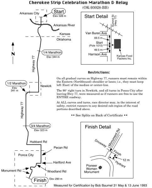
The Cherokee Strip Marathon, a point-to-point course from Arkansas City, KS to Ponca City, OK, illustrates a single-line map. (This also happens to be a computer-drawn map, which is becoming more common as suitable graphics software has become widely available.) Sometimes, especially for long courses such as marathons, it isn't practical to draw a line depicting the measured path through the entire course. In such cases, it is acceptable to draw the road as a single line, as long as the actual measured/certified path is clearly described. For this particular course, the measured/certified path was chosen as a well-defined path that can be easily described, although it's probably not safe for runners to run this path (unless the course could be closed to traffic, which isn't likely in a small rural race). Therefore, the map also advises that, in the interest of safety, the race director may restrict runners to any desired sub-region of the allowed road portions—which would force runners to run longer than the measured distance. It is always acceptable for race directors to impose additional restrictions of this sort. However, care must be taken to make sure that runners never run shorter than the measured distance.
Still more complicated course maps could be shown, but they would just be comprised of more of the same kinds of features. Remember, the best course is the simplest course; i.e., the one that requires the least monitoring and is easy for the runners to follow. The more complicated the course, the more monitors you need and the longer the course map will take to draw (and there is also a greater risk of something going wrong on race day). The more turns you have, the slower the course will be for the runners. Start with something simple.
| Go to Next Section: | Appendix D - Adjusting an Existing Certified Course |
| Previous Section: | Appendix C - Example - Measuring the Race Course |
| Back to: | Table of Contents |